 The map of Ortelius A.D. 1584 shows Muar as a town at the south of Melaka. The history of Muar started since the times of the Hindu empire. According to history, the name Muar appeared much earlier than the Melaka empire existed. In 1361, there was a Bhuddist monk (a religious adviser in Majapahit Palace) named Prapanca wrote the famous poetry, Nagarakertagama. This poetry recorded the history of the empire of Majapahit in the Malay peninsular. The king was Hayam Wuruk and his prime minister was Gajah Mada (1350 - 1389). Muar was one of the state under this empire.
There are other souces of history that proof the early existence of Muar before Melaka. Barros wrote in 1553 about Parameswara (Paramicura), founder of the Melaka empire, was exiled from Temasik (Singapore) after he killed the king. He stopped at Muar and built a wooden fort at a place called Pagoh. In Sejarah Melayu, Temasik which then was ruled by Sultan Iskandar Syah, was defeated by the Majapahit empire. Sultan Iskandar Syah moved to Muar. Here he opened two areas near the river Muar called Biawak Busuk and built a fort named Kota Buruk. He eventually moved to Melaka and built its empire. One event that proved the close relationship between Muar and Melaka was that in 1488, Sultan Alauddin Riayat Syah 1, died in Pagoh, Ulu Muar and was buried there.
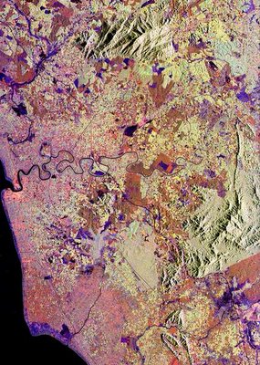
This spaceborne radar image shows patterns of agricultural development in Muar. The city of Muar is at the center of the left edge of the image at the mouth of the Muar River (Sungai Muar). The city is about 150 km (93 miles) southeast of Malaysia's capital Kuala Lumpur, and about the same distance northwest of Singapore. The coast at the left side of the image is on the Strait of Malacca, the narrow waterway separating Malaysia and the Indonesian island of Sumatra. Blue areas along the coast are tidal marshes. The fine patchwork patterns seen across the image in yellow and orange are groves of rubber, banana and oil palm trees, the dominant agricultural products of the region. Fields of other seasonal crops appear in darker shades of orange and purple. A sharp boundary is seen in the lower right between native forest in light green and clear-cut croplands in orange. This image was acquired by Spaceborne Imaging Radar-C/X-Band Synthetic Aperture Radar (SIR-C/X-SAR) onboard the space shuttle Endeavour on April 18, 1994. The image is 68.2 kilometers by 48.7 kilometers (42.3 miles by 30.2 miles) and is centered at 2.2 degrees North latitude, 102.7 degrees East longitude. North is toward the upper right. The colors are assigned to different radar frequencies and polarizations of the radar as follows: red is L-band, horizontally transmitted and received; green is L-band, horizontally transmitted, vertically received; and blue is C-band, horizontally transmitted, vertically received. This is another image for Muar, from IKONOS, 1m resolution,I got from CRISP...viva la a'Muar'ican!!!